DRAW Coastline / Lakes and Rivers / Prefecture boundary (WSHORE)
WSHORE, RSHORE, PSHORE
NAME
wshore - Draw coast, lake and rivers with small scale
rshore - Define the range to draw coastlines etc. by 'pshore'
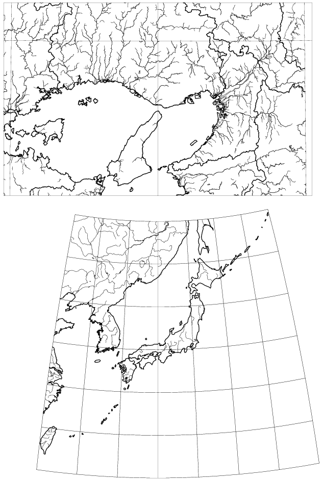
pshore - Draw coast, lake, rivers, prefecture boundary with larger scale
All the data used to draw coastlines etc. are stored under the directory
/home/SHARE/data/shore/. The coarse data files "wcoast.jpn", "wriver.jpn",
and "world.cst" contain Lat. and Lon. values (in minutes, integer) and are
used by 'wshore'. This data does not have the resolutiuon of distinguishing
the geodetic system.
The data used by 'pshore' are stored with subdirectory structure of the
name Z?? and t??, and the filenames NiiEkkk.coast, NiiEkkk.river, and
NiiEkkk.prefb for each 1 deg.Lat. x 1 deg.Long. area, SW corner of which is
ii deg.N Lat. and kkk deg.E Long. Here the filename extensions .coast,
.river, and .prefb indicate coastlines data, rivers and lakes, and
prefecture boundaries, respectively. The subdirectory Z?? cooresponds to
the WGS position data of UTM zone ??, and t?? to Tokyo datum positions.
The contents of those files are the sequence of curve data, and a curve data
is composed of multiple pairs of Lat. and Long. (node) data (in 0.01 minute,
integer relative to SW corner of the area) preceded by the number of pairs
constituting the curve.
Users may place their own data of drawing coastlines etc. by 'pshore'
under the directory /home/SHARE/data/shore/ (as defined by symbolic constant
DIRSHORE in 'wshore.c' source), with subdirectory tree structure with UTM
zone number, and naming rule of data files above. [For southern hemisphere
N?? may be alternated by S?? (south latitude), and also E### by W### (west
longitude) for western hemisphere (still corresponding to SE corner of the
range).]
SYNOPSIS
call rshore(m, is, in, kw, ke)
m [int] Specify whether WGS (m=1) or old Tokyo Datum (m=0) to
use as a reference geodetic system.
Must be m=1 or m=0.
is, in [int] Specify South bound and North bound latitudes to draw.
kw, ke [int] Specify West bound and East bound longitudes to draw.
This assignement is effective only for 'pshore' drawing.
Map data for Larger scale are prepared only around Japan
(Latitude range of 20-50 deg.N and Longitude range of 120-155
deg.E), although users can place their own data to expand.
external conv
call wshore(xorg, yorg, mpen, scl, conv)
call pshore(xorg, yorg, mpen, scl, conv)
xorg, yorg [float] Coordinates (in cm) of the origin in the drawing.
mpen [int] Specify pen numbers to draw coast / lakes and rivers /
prefecture boundary in the form of 3 digits number:
pen numbers for prefecture boundary / lakes and rivers
/ coast on the digits of 100 / 10 / 1 , respevtively.
If a digit is 1-8, lines are drawn by its pen number,
and if it is 0 corresponding information is not drawn.
As a special case for 'wshore', mpen=99 or mpen=999 is
accepted to draw the coast of world with the current pen,
for the range of 0 deg. to 360 deg. Long. (Pacific mode)
[mpen=99] or for the range of -180 deg. to +180 deg.
(Atlantic mode) [mpen=999].
scl [float] Reduction rate. Coordinate values of scl given by 'conv'
is represented by 1 cm of length on the drawing.
(If the coordinate values are in km, the drawing scale is
1 : (scl*100,000) .)
conv [ext.symb.] External procedure name to define projection, i.e.,
the name of subroutine with 4 arguments as follows:
subroutine conv(alat, alon, xe, yn)
where Lat. (alat) and Lon. (alon) [in minutes] is
converted into drawing coordinates toward right (xe)
and upward (yn).
This argument 'conv' may be user-defined, or the Map Projection
(XYCONV) 'cviken' routine is useful for this purpose. Here,
the projection number, origin, etc. must be assigned at calling
'cvinit', and its geodetic system should coincide with the
selection by calling 'rshore'.
EXAMPLE
!----------
external cviken
call cvinit(100, 35.*60., 135.*60., 0., 0.)
call psopn("wshore.ps","A4P")
call plots(2., 2.)
call plot(8., 7., -3)
call wshore(0., 0., 12, 250., cviken)
do i=20,50,5
call cviken(float(i*60), 7200., xe, yn)
call plot(xe/250., yn/250., 3)
do k=121,155
call cviken(float(i*60), float(k*60), xe, yn)
call plot(xe/250., yn/250., 2)
enddo
enddo
do k=120,155,5
call cviken(1200., float(k*60), xe, yn)
call plot(xe/250., yn/250., 3)
do i=21,50
call cviken(float(i*60), float(k*60), xe, yn)
call plot(xe/250., yn/250., 2)
enddo
enddo
call plot(0., 16., -3)
call wrect(-8., -8., 16., 10.)
call scisor(-8., -8., 16., 10.)
call cvinit(253, 0., 0., 0., 0.)
call cviken(float(35*60), float(135*60), xo, yo)
call rshore(1, 34, 36, 133, 136)
call pshore(-xo/12., -yo/12., 212, 12., cviken)
call plot(-8., 0., 3)
do k=-90,90
call cviken(float(35*60), float(135*60+k), xe, yn)
call plot((xe-xo)/12., (yn-yo)/12., 2)
enddo
do k=134,136
call plot(0., -8., 3)
do i=-60,30
call cviken(float(35*60+i), float(k*60), xe, yn)
call plot((xe-xo)/12., (yn-yo)/12., 2)
enddo
enddo
call plote
call pscls
stop
end