DRAW Coastline / Lakes and Rivers / Prefecture boundary (WSHORE)
WSHORE, RSHORE, PSHORE
NAME
wshore - Draw coast, lake and rivers with small scale
rshore - Define the range to draw coastlines etc. by 'pshore'
pshore - Draw coast, lake, rivers, prefecture boundary with larger scale
SYNOPSIS
call rshore(m, is, in, kw, ke)
call rshore(is, in, kw, ke)
m [int] Specify whether old Tokyo Datum (m¡á0) or WGS (m¡á1) to
use as a reference geodetic system.
Must be m=0 or m=1. Otherwise, the calling is treated as
the second form with 4 arguments, where old Tokyo Datum
(m¡á0) is assumed.
is, in [int] Specify latitude range to draw.
Must be 20 <= is < in <= 50 .
kw, ke [int] Specify longitude range to draw.
Must be 120 <= kw < ke <= 155 .
external conv
call wshore(xorg, yorg, mpen, scl, conv)
call pshore(xorg, yorg, mpen, scl, conv)
xorg, yorg [float] Coordinates (in cm) of the origin in the drawing.
mpen [int] Specify pen numbers to draw coast / lakes and rivers /
prefecture boundary in the form of 3 digits number:
pen numbers for prefecture boundary / lakes and rivers /
coast on the digits of 100 / 10 / 1 , respevtively.
As a special case, if mpen=99, the coast of world is
drawn by current pen.
scl [float] Reduction rate. Coordinate values of scl given by 'conv'
is represented by 1 cm of length on the drawing.
(If the coordinate values are in km, the drawing scale is
1 : (scl*100,000) .)
conv [ext.symb.] External procedure name to define projection, i.e.,
the name of subroutine with 4 arguments as follows:
subroutine conv(alat, alon, xe, yn)
where Lat. (alat) and Lon. (alon) is converted into
drawing coordinates toward right (xe) and upward (yn) .
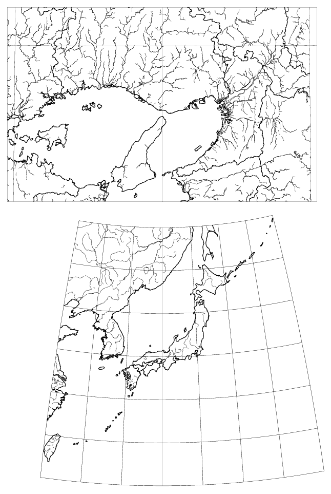
EXAMPLE
external cviken
call cvinit(100, 35.*60., 135.*60., 0., 0.)
call psopn("wshore.ps","A4P")
call plots(2., 2.)
call plot(8., 7., -3)
call wshore(0., 0., 12, 250., cviken)
do 50 i=20,50,5
call cviken(float(i*60), 7200., xe, yn)
call plot(xe/250., yn/250., 3)
do 50 k=121,155
call cviken(float(i*60), float(k*60), xe, yn)
call plot(xe/250., yn/250., 2)
50 continue
do 60 k=120,155,5
call cviken(1200., float(k*60), xe, yn)
call plot(xe/250., yn/250., 3)
do 60 i=21,50
call cviken(float(i*60), float(k*60), xe, yn)
call plot(xe/250., yn/250., 2)
60 continue
call plot(0., 16., -3)
call wrect(-8., -8., 16., 10.)
call scisor(-8., -8., 16., 10.)
call cvinit(253, 0., 0., 0., 0.)
call cviken(float(35*60), float(135*60), xo, yo)
call rshore(1, 34, 36, 133, 136)
call pshore(-xo/12., -yo/12., 212, 12., cviken)
call plot(-8., 0., 3)
do 70 k=-90,90
call cviken(float(35*60), float(135*60+k), xe, yn)
call plot((xe-xo)/12., (yn-yo)/12., 2)
70 continue
do 80 k=134,136
call plot(0., -8., 3)
do 80 i=-60,30
call cviken(float(35*60+i), float(k*60), xe, yn)
call plot((xe-xo)/12., (yn-yo)/12., 2)
80 continue
call plote
call pscls
stop
end