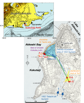
第1図.厚岸地域の調査地点(A-1〜5)および調査測線図,1843年津波の推定浸水域および汐見川上流におけるTs3の分布範囲.国土地理院発刊の1:25000地形図「厚岸」を基図として使用.
Fig. 1. Study sites (A-1~5), survey line along the Shiomi-gawa River, inferred inundation area of 1843 tsunami and distribution limit around upper stream of the Shiomi-gawa River in Akkeshi Town.
|
 [拡大] [拡大] |
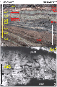
第2図.A-3地点におけるトレンチ壁面(a) ,およびAs3層準の軟X線写真(b).
Fig. 2. Tephra layers and tsunami sands interbedded by peat layers on the southwestern wall at A-3 trench site (a) and a radiograph of As3 layer showing graded bedding with lamina (b).
|
 [拡大] [拡大] |