 | |
| シリーズ名 | 海洋地質図 |
| 番 号 | 51 |
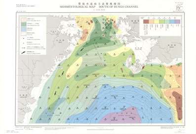
| 図 名 | 豊後水道南方表層堆積図 Sedimentological Map South of Bungo Strait |
| 縮 尺 | 1:200,000 |
| 付 図 | 1. 三角ダイヤグラムに基づく底質分布図 2. 砂粒組成分布図(0.25-0.3mm) |
| 説明書 | 付属 |
| 著 者 | 池原 研 |
| 発行年 | 1999 |
| 発行者 | 地質調査所(現 産総研 地質調査総合センター) |
| 販売価格 | ¥4,070 【 購入方法 】 |
| 備 考 | |
| |
| シリーズ名 | 海洋地質図 |
| 番 号 | 51 |
| 図 名 | 豊後水道南方表層堆積図 Sedimentological Map South of Bungo Strait |
| 縮 尺 | 1:200,000 |
| 付 図 | 1. 三角ダイヤグラムに基づく底質分布図 2. 砂粒組成分布図(0.25-0.3mm) |
| 説明書 | 付属 |
| 著 者 | 池原 研 |
| 発行年 | 1999 |
| 発行者 | 地質調査所(現 産総研 地質調査総合センター) |
| 販売価格 | ¥4,070 【 購入方法 】 |
| 備 考 | |