静岡地震 [2009年8月11日]
2009年8月11日 静岡地震の関連資料
2009年08月12日 開設
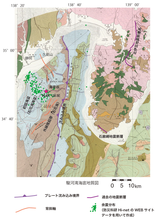
1.駿河湾海底地質図における震央位置
(位置情報は高感度地震観測網(防災科学技術研究所)発表のデータによる。)
資料は、駿河湾海底地質図(地質調査所,海洋地質図52,1999)
2.近隣陸域地質図における関連資料
資料は
1/5万地質図幅「清水」(地質調査所,1990)抜粋
(pdf file:5map_shimizu.pdf / 790 KB)
3.本地震の関連文献
Yasuo AWATA and Yuichi SUGIYAMA,1989
Title Geological structure due to the right-lateral reverse faulting accompanied with the large earthquakes along the Nankai trough
粟田泰夫,杉山雄一
南海トラフ沿いの巨大地震に伴う右横ずれ逆断層構造
地震 第2輯, 42, 2, 1989, pp.231-233.
Keywords テクトニクス,海底,南海トラフ
Yuichi SUGIYAMA,1990
Seismotectonics of the Suruga bay and Enshu-nada region
杉山雄一
駿河湾~遠州灘地域のサイスモテクトニクス
地震 第2輯, 43, 3, 1990, pp.439-442.
Keywords テクトニクス,,東海
Matsumura, S. (1997) Focal zone of a future Tokai earthquake inferred
from the seismicity pattern around the plate interface, Tectonophysics,
273, 271-291.
Toda, S. and S. Matsumura (2006) Spatio-temporal stress states estimated
from seismicity rate changes in the Tokai region, central Japan, Tectonophysics,
417, 53-68.
データベース
活断層データベース
-
日本の活断層に関係する総合データベースです。
-
インターネットを利用してご覧いただける地質図です。
地震に関する地下水観測データベース(WellWeb)
※8/11の駿河湾の地震の後の地下水変化を事例データベースにアップしました。
・地震前後における地下水変化事例データベースindex
・8/11の駿河湾の地震の後の地下水変化の資料本体(pdf 1)
・8/11の駿河湾の地震の後の地下水変化の資料本体(pdf 2)
関連リンク
問い合わせ先
-
地震・津波研究情報
- 令和6年(2024年)能登半島地震の関連情報
- 令和5年(2023年)10月鳥島近海の地震に関する情報
- 令和5年(2023年)5月5日に石川県能登地方で発生した地震の関連情報
- 2023年2月6日に発生したトルコ南部の地震(Mw 7.8)に関する情報
- 令和4年(2022年)6月19日に能登半島で発生した地震の関連情報
- 令和3年(2021年)10月7日に千葉県北西部で発生した地震の関連情報
- 令和3年(2021年)9月16日に能登半島で発生した地震の関連情報
- 令和元年(2019年)6月18日に山形県沖で発生した地震の関連情報
- 平成31年(2019年)1月3日に熊本県熊本地方で発生した地震の関連情報
- 平成30年北海道胆振東部地震の関連情報
- 平成30年(2018年)6月18日に大阪府北部で発生した地震の関連情報
- 平成30年(2018年)4月9日に島根県西部で発生した地震の関連情報
- 平成28年(2016年)12月28日の茨城県北部の地震に関する情報
- 平成28年(2016年)11月22日福島県沖の地震の関連情報
- 2016年11月14日に発生したニュージーランド南島の地震(Mw7.8)に関する情報
- 平成28年(2016年)鳥取県の中部に発生した地震に関する情報
- 平成28年(2016年)熊本地震及び関連情報
- 長野県北部の地震[2014年11月22日]
- 2013年4月13日淡路島付近の地震
- トルコ東部の地震 [2011年10月23日]
- 東北地方太平洋沖地震 [2011年3月11日]
- 中国青海省地震 [2010年4月14日]
- 静岡地震 [2009年8月11日]
- 岩手県沿岸北部 [2008年7月24日]
- 岩手・宮城内陸地震 [2008年]
- 中国四川省地震 [2008年]
- 新潟県中越沖地震 [2007年]
- 能登半島地震 [2007年]
- パキスタン地震 [2005年]
- 福岡県西方沖地震 [2005年]
- スマトラ沖地震・津波情報 [2004年、2005年]
- 新潟県中越地震 [2004年]
- 十勝沖地震 [2003年]
- 宮城県沖・北部地震 [2003年]
- 火山研究情報
- 土砂災害研究情報
- その他の地質災害研究情報