Cover and Back cover
Cover:
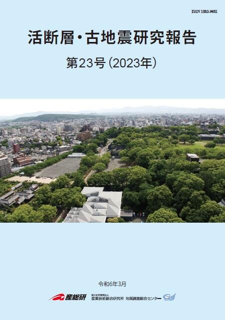
Eastward panoramic bird view from the Kumamoto Castle Park
The Tatsutayama fault traces feet of hummocky mountains (Mt. Tatsutayama and Mt. Iwakurayama), which we can find at back left of the photo. The fault is estimated to extend westward passing through the north facing scarp developed in the Kumamoto Castle Park, just below the shutter point. The Kumamoto Castle Park locates on the plateau formed by pyroclastic deposit erupted from Mt. Aso, which we can see as skyline. To evaluate the activity of the fault, we conducted drilling survey at both sides of the scarp to determine geological structure and stratigraphy around the scarp. See details in text (Ota et al.) in this issue.
Back cover:
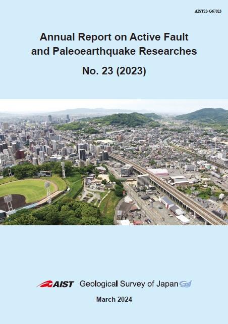
Westward panoramic bird view from the Kumamoto Castle Park
The Tatsutayama fault is estimated to extend westward from the north facing scarp (developed on the right side of the baseball ground) in the Kumamoto Castle Park. The fault trace is estimated to pass under the elevated railroad of the Kyushu shinkansen and traced along northern feet of isolated hummocky mountains (Mt. Hanaokayama, Mt. Dokkosan, Mt. Jouzan and Mt. Obouyama, from front to back), which linearly aligned towards the Shimabara Bay (the back of the photo). We can recognize the northern slopes of these mountains are steeper than the southern slopes. This asymmetric shape of the mountains suggests existence of geological structure including faulting. See details in text (Ota et al.) in this issue.
- About GSJ
- Our Activities
- Purchase guide
-
Publications and Database
- information
- Bulletin of the Geological Survey of Japan
- bull2024(Vol.75)
- bull2023(Vol.74)
- bull2022(Vol.73)
- bull2021(Vol.72)
- bull2020(Vol.71)
- bull2019(Vol.70)
- bull2018(Vol.69)
- bull2017(Vol.68)
- bull2016(Vol.67)
- bull2015(Vol.66)
- bull2014(Vol.65)
- bull2013(Vol.64)
- bull2012(Vol.63)
- bull2011(Vol.62)
- bull2010(Vol.61)
- bull2009(Vol.60)
- bull2008(Vol.59)
- bull2007(Vol.58)
- bull2006(Vol.57)
- bull2005(Vol.56)
- bull2004(Vol.55)
- bull2003(Vol.54)
- bull2002(Vol.53)
- bull2001(Vol.52)
- Bulletin of the Geological Survey of Japan(old)
- Annual Report on Active Fault and Paleoearthquake Researches
- Reports, Geological Survey of Japan
- CCOP-GSJ Groundwater Project Report
- CCOP Technical Bulletin
- Cruise Report
- Geological Hazards
- Learning and Education
- GSJ Database Collection
- Collection of links