Geology of Japan
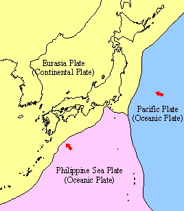 The Japanese archipelago is part of the island arcs along the northwestern margin of the Pacific Ocean. It is located at the eastern end of the Eurasian Plate at the junction of the Pacific and Philippine Sea Plates. Geohistorically, Japan had been built by the subduction tectonics including accretionary tectonics, large scale metamorphism, magmatism and volcanism. Its geology is composed mainly of accretionary complex, metamorphic rocks, plutonic and volcanic rocks and surface sediments.
 The 1:200,000 Seamless Digital Geological Map of Japan shows detailed distribution of each geological unit based on the original legend. In general, distributional trend of each unit is parallel to the elongation of the island arc. Quaternary volcanic products are distributed along the backbone area showing the volcanic front. Older formations are deformed and displaced by the faults and folds. In addition, many faults are present also in the younger formations. Sedimentary and volcanic rocks younger than Neogene cover a wide area especially in the northeastern Japan.
The general overview of the basement rocks of Japan is shown below. This map shows the distribution of the basement rocks classified mainly by the age of accretionary complex and metamorphic rocks with major tectonic lines.
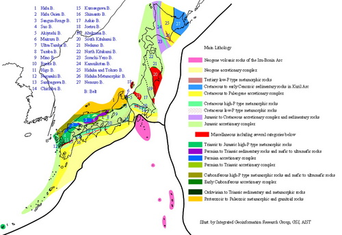
In northeastern Japan, the distribution and structure of the basement rocks is obscure because the basement rocks are covered by thick sediments and volcanic products developed after Neogene. In southwestern Japan, the age of the basement rocks become systematically younger from NW to SE across the island. However, the geohistory of Japan is not fully understood and many researches are implemented to have a better understanding about its evolution.