Nishiki and Miyagi (2011)
Observations of the ever-changing volcanic plume from Showa crater, Sakurajima volcano, Kyushu Japan
- Authors
- Kuniaki NISHIKI and Isoji MIYAGI (Geological Survey of Japan, AIST)
- GSJ Open-file Report, no. 542
Contents
In the recent three decades, eruptions of Sakurajima volcano occurred at the Showa crater and Minami-dake summit crater.
The current center of the activity is the Showa crater (31° 34' 43"N, 130° 39' 45"E) located about 750 m above sea level on the east side hill of the summit of the Minami-dake.
The Showa crater commenced the activity on 26th October 1939 and ceased by 1948.
Since 1948 the Minami-dake summit crater was the only active center of Sakurajima volcano until the recommencement of Showa crater.
The Showa crater re-activated on June 2006.
On 3rd February 2008 explosive eruptions started.
Since the middle of April of 2008, red-hot ejecta have become observed in night by network cameras installed around the volcano.
We present photographs of volcanic plume from the Showa crater observed on 19th and 21st March 2010.
The camera we used was a digital single lens reflex camera Canon EOS Kiss Digital X2 with a single focal length lens (EF400mm F5.6 L) and a zoom lens (EFS18-55mm F3.5-5.6 IS).
We iterated shooting every 5s or 30s.
Color balance, aperture and exposure time were set automatically.
A digital SLR camera have advantage over a digital video in terms of its detail images owing to the high performance large-aperture lens.
Although, the movie file size is scale down due to capacity, we will provide the original images for research and education.
Observation spots
We photographed the volcanic cloud of the Showa crater(31°34′43″N,130°39′38″E) from three good view sites (Fig.1). Slant distances from the crater are about 11.3 km(Futagawa, Tarumizu city; 31°34′38″N,130°46′47″E), about 6.6 km (Kaigata fishing port; 31°31′45″N,130°42′00″E) and about 3.8 km(Kurokami branch observatory; 31°35′01″N,130°42′02″E).
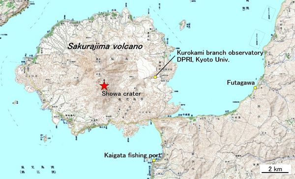
- Fig.1. Locarity map
Condition of shoot and making movies
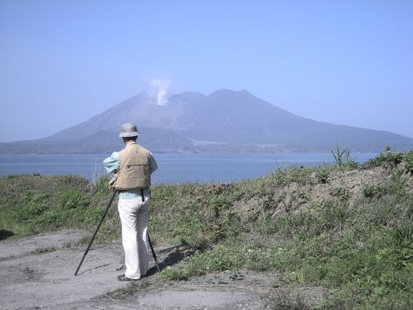
- Fig.2.Observation from Futagawa, Tarumizu city.
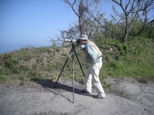
- Fig.3.Photographic Equipment(situation with 400mm lense)
Results
At Futagawa, Tarumizu city
- Observation spot:ca.11.3 km east of the Showa crater. (31°34′38″N,130°46′47″E)
- Date:2010.3.19 9:50-10:00 Interval;5sec(Movie 1) (->download photos)
- Remarks:Rising white plume from the Showa crater was observed continuously. As the plume from the Showa crater was tilted the north side(right side of picture), we were able to watch the plume from the Minamidake crater back the Showa crater.

At Kaigata fishing port
- Observation spot:ca.6.6 km southeast from the Showa crater. (31°31′45″N,130°42′00″E)
- Date:2010.3.19 17:30-18:00 Interval;30sec(Movie 2) (->download photos)
- Remarks:After the plume since about 17:30 was temprarily weakend, gray plume including volcanic ash was erupted three times(17:42, 17:46, 17:50).

At Kurokami branch observatory, DPRI, Kyoto Univ.
- Observation spot:ca.3.8 km east-southeast from the Showa crater. (31°35′01″N,130°42′02″E)
- Date:2010.3.19 12:18-12:30 Interval;5sec(Movie 3) (->download photos)
- Remarks: The plume was rised continuosly from the north side(right side of picture) in the Showa crater, but around 12:25, the plume was reduced temporarily around 30s. Then, the plume began to rise from the middle of the Showa crater.

- Date:2010.3.21 11:13-11:23 Interval;5sec(Movie 4) (->download photos)
- Remarks: The weak white plume was rised intermittently from in the north side(right side of picture) of the Showa crater.

- Date: 2010.3.21 13:10-13:26 Interval;5sec(Movie 5) (->download photos)
- Remarks: While rising white plume from the Showa crater was observed continuously, gray ash plume was rised at 13:10. Consecutively, the weak gray ash plume was rised intermittently at 13:14 and 13:20.
